

Cyclone Fengal Storm LIVE Updates: Flights connecting Chennai have been impacted.
Cyclone Fengal LIVE Updates: Cyclone Fengal – pronounced ‘Feinjal’ – is likely to make landfall this evening between Karaikal and Mahabalipuram with a wind speed of 70-80 km per hour, gusting up to 90 kmph, the Indian Meteorological Department said. Chennai, Tiruvallur, Kancheepuram, Kallakurichi, Cuddalore districts, and Puducherry are bracing for heavy rain. The Chennai airport has been shut till the evening while the local train frequency has been reduced due to the adverse weather.
Here are the live updates on Cyclone Fengal:
Cyclone Fengal: Man Electrocuted At ATM In Chennai, Cops Suspect Short Circuit
A man was electrocuted at an ATM in Chennai amid heavy rain with cops suspecting short circuit on a railing outside.
#WATCH | Tamil Nadu: Road being cleared by the officials as trees uprooted in Chennai’s Besant Nagar area due to gusty winds and rain amid #CycloneFengal
As per IMD, #CycloneFengal to cross north Tamil Nadu-Puducherry coasts between Karaikal and Mahabalipuram close to… pic.twitter.com/FcPeZkklL5
– ANI (@ANI) November 30, 2024
Cyclone Fengal May Uproot Trees, Damage Telephone And Power Lines: IMD Chief
“Cyclone Fengal is very likely to move slowly westwards and hit the north Tamil Nadu coast around this evening and when it approaches the coast, it is very likely to have wind speed of 70-80 km/h. These winds may uproot small trees, cause damage to houses, telephone lines and power lines. Along with this, heavy to very heavy rainfall has been recorded in the past 24 hours at a few places, especially over the North coast of Tamil Nadu and some places of South Andhra Pradesh. In the next 24 hours, heavy to very heavy rainfall is expected over South Andhra Pradesh and North Coastal Tamil Nadu districts. There is a possibility of inundation in low-lying areas and cities like Chennai, Mahabalipuram. People should not come out of their homes and should stay in safe places. Fishermen should not venture into the sea,” said IMD DG Mrutyunjay Mohapatra.
#WATCH | Puducherry CM N Rangaswamy met Puducherry collector A Kulothungan to discuss preparations done ahead of the landfall of #CycloneFengal
As per IMD, #CycloneFengal to cross north Tamil Nadu-Puducherry coasts between Karaikal and Mahabalipuram close to Puducherry as a… pic.twitter.com/bdRVsWLMad
– ANI (@ANI) November 30, 2024
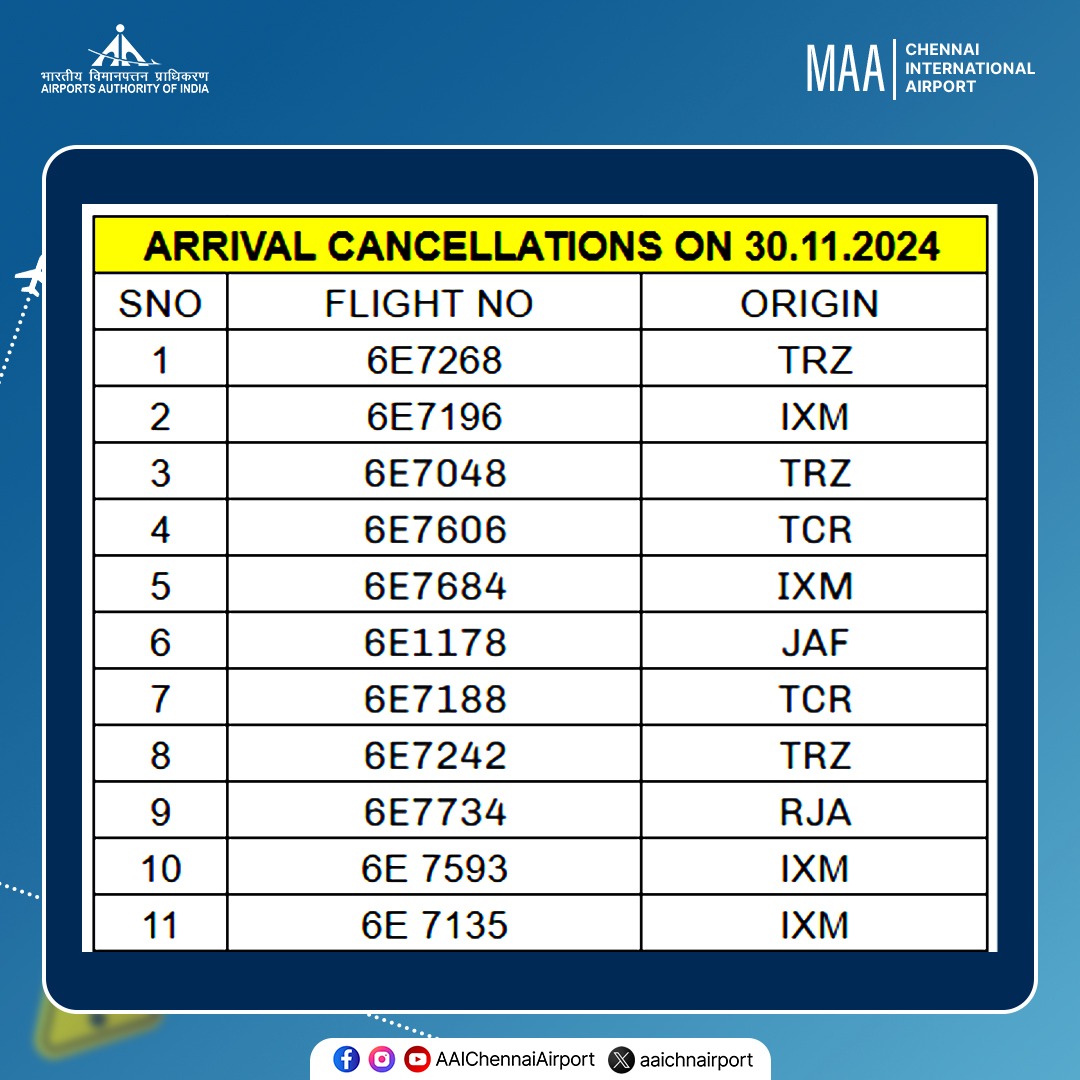
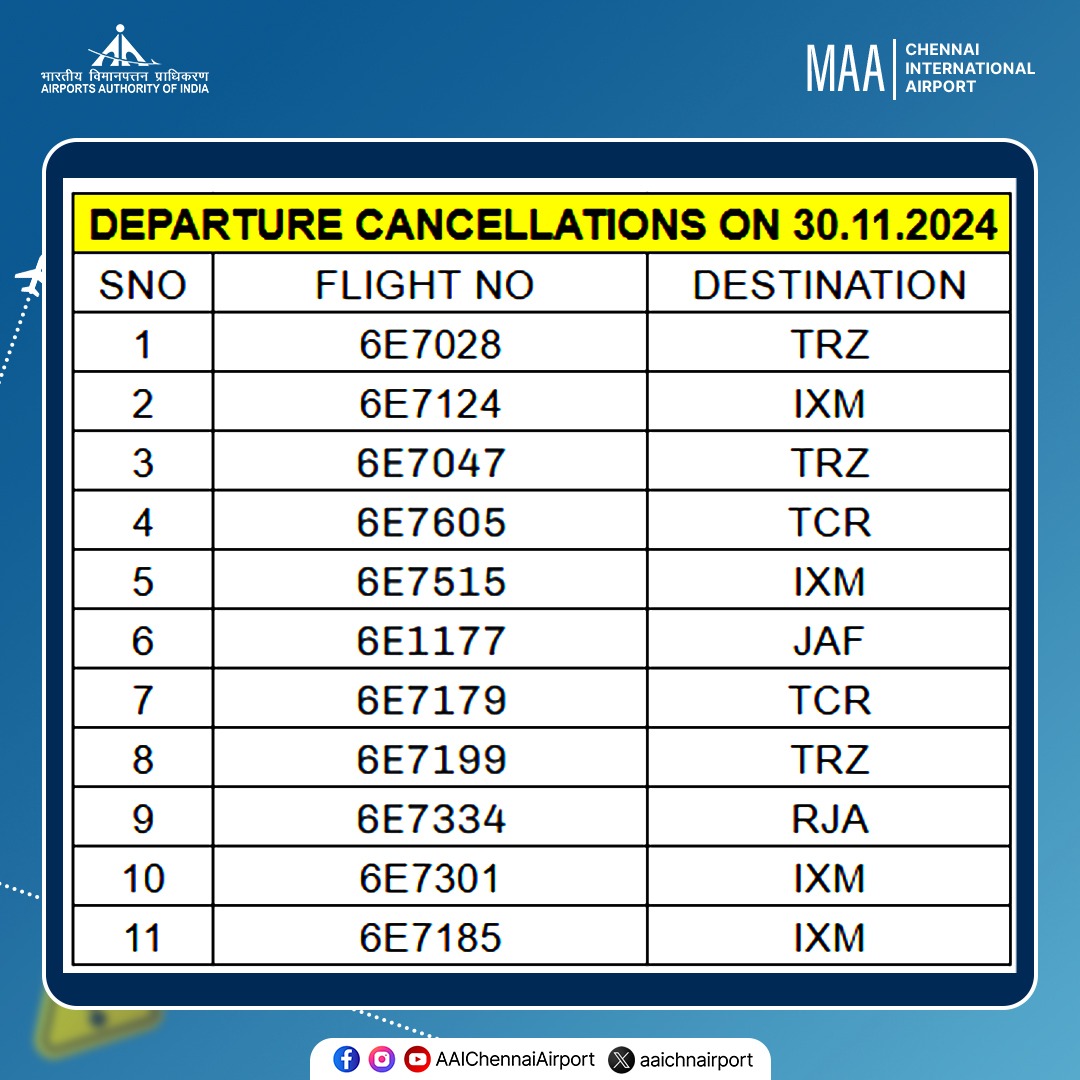
- Air India flight AI0439 (A321, VT-PPL) from Delhi to Chennai, scheduled to arrive at 0855 hrs, has been diverted to Bengaluru.
- Air India flight AI0550 (A320, VT-CIN) from Port Blair to Chennai, scheduled to arrive at 1010 hrs, has been diverted to Bengaluru.
- FitsAir flight 8D0831 (A320, 4R-EXR) from Colombo to Chennai, scheduled to arrive at 1020 hrs, has been diverted to Colombo.
- IndiGo flight 6E0243 (A320, VT-IAQ) from Hyderabad to Chennai, scheduled to arrive at 0900 hrs, has been diverted to Hyderabad.
- IndiGo 6E1412 (A320, VT-IPT) from Abu Dhabi to Chennai, scheduled to arrive at 0810 hrs, has been diverted to Bengaluru.
Due to strong winds with velocities ranging between 65-73 kmph, suburban services between Chennai Beach and Velachery in the MRTS Section have been suspended from 12:15 hrs onwards, notifies the Chennai division PRO.
Helpline Numbers for Passenger Assistance:
1. Comm Control – 044-25330952, 044-25330953
2. Central – 044-25354140 & 22277
3. Egmore – 9003161811
4. Tambaram – 8610459668
5. Chengalpattu – 9345962113
6. Perambur – 9345962147
Cyclone Fengal News: Chennai Airport To Stay Shut Till 7 pm Due To Adverse Weather
Chennai airport suspends operations from 12:30 pm till 7 pm due to higher crosswinds forecast by the Met department.
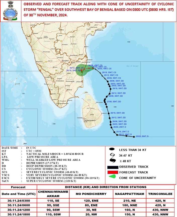
“Yesterday’s Deep Depression over Southwest Bay of Bengal intensified into Cyclonic Storm “FENGAL” [pronounced as FEINJAL]. The Cyclonic Storm “FENGAL” over Southwest Bay of Bengal moved west-northwestwards with a speed of 13 kmph during past 6 hours and lay centred at 0830 hours IST of today, the 30th November 2024 over the same region near latitude 12.3°N and longitude 80.9°E, about 120 km east-northeast of Puducherry, 110 km southeast of Chennai, 200 km north-northeast of Nagappattinam and 420 km north of Trincomalee.
It is likely to move nearly westwards and cross north Tamil Nadu-Puducherry coasts between Karaikal and Mahabalipuram close to Puducherry as a cyclonic storm with a wind speed of 70-80 kmph gusting to 90 kmph during evening of 30th November.” – IMD
#WATCH | Tamil Nadu: Waterlogging witnessed in parts of Chennai district amid heavy rainfall
As per IMD, #CycloneFengal to cross north Tamil Nadu-Puducherry coasts between Karaikal and Mahabalipuram close to Puducherry as a cyclonic storm with a wind speed of 70-80 kmph gusting… pic.twitter.com/esoaIzSgtF
– ANI (@ANI) November 30, 2024

An excavator is removing a tree that has fallen due to heavy rains on North Avenue Canal Road, Korattur in Chennai.
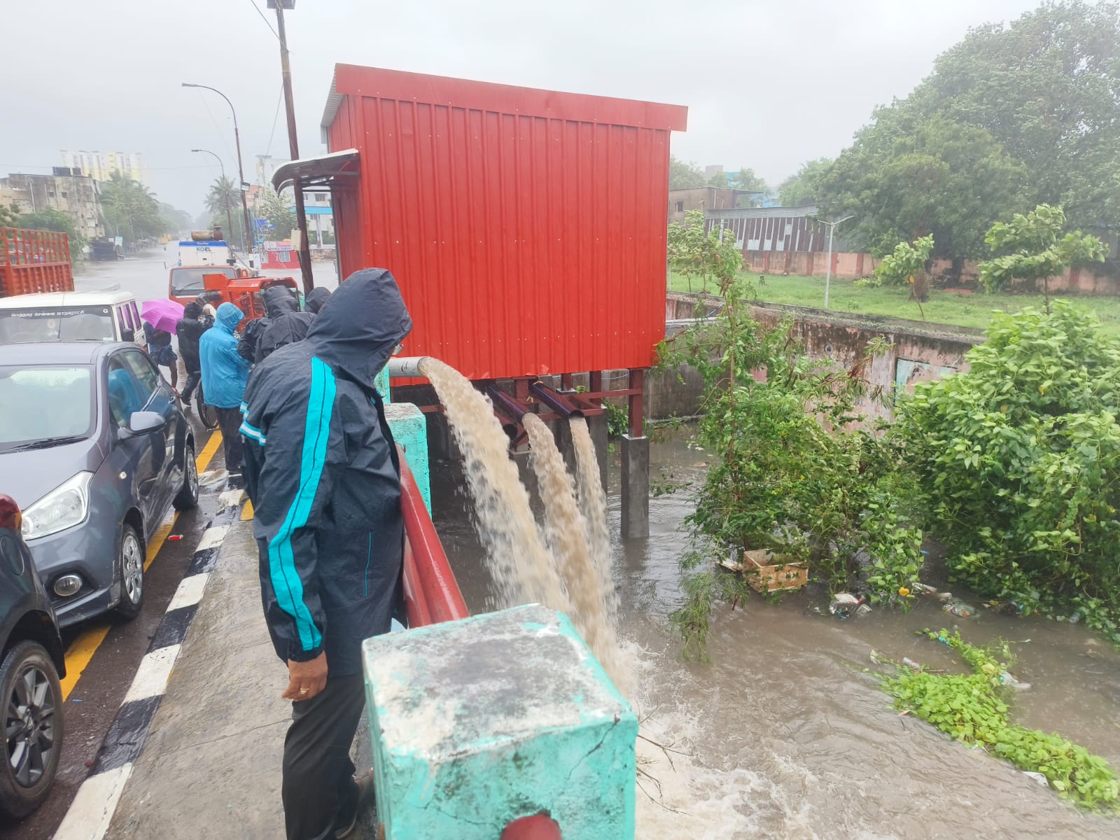
Chennai civic body using motors at Mullai Nagar to handle the flow of rainwater.

“The weather department has warned that there will be continuous rain for the next 2-3 days. Tamil Nadu government is constantly monitoring and taking precautionary measures. It has been reported the cyclone will cross the coast tonight. Relief work is going on. Relief camps have been set up and people are being accommodated there. Other districts are also being monitored continuously. There has been no incident so far,” says Tamil Nadu Chief Minister MK Stalin.
IndiGo airlines has suspended all flight operations at Chennai airport while Air India flights connecting the city have been impacted due to the adverse weather ahead of the landfall of Cyclone Fengal.
“IndiGo Airlines @IndiGo6E has temporarily suspended all arrival and departure flight operations at Chennai Airport due to adverse weather conditions. Flight operations will resume once the weather improves, prioritising the safety of passengers and crew. We recommend passengers check with their respective airlines for real-time updates,” said Chennai Airport in a post.
Air India said in a post that flights to and from Chennai are getting affected due to inclement weather and heavy rains. It also asked the fliers to check your flight status before heading to the airport.
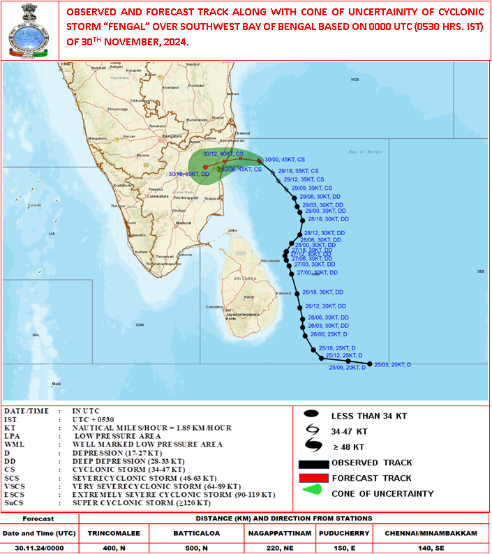
“Cyclonic Storm “FENGAL” over Southwest Bay of Bengal moved west-northwestwards with a speed of 12 kmph during past 6 hours and lay centred at 0530 hours IST of today, the 30th November 2024 over the same region near latitude 12.2°N and longitude 81.2°E, about 150 km east of Puducherry, 140 km southeast of Chennai, 210 km northeast of Nagappattinam and 400 km north of Trincomalee. To move nearly westwards and cross north Tamil Nadu-Puducherry coasts between Karaikal and Mahabalipuram close to Puducherry as a cyclonic storm with a wind speed of 70-80 kmph gusting to 90 kmph during evening of 30th November.” – IMD

Dos
- Stay Indoors: Remain inside your home and switch off electrical mains and gas supply to prevent fires and gas leaks.
- Secure Your Space: Close all doors and windows to protect against strong winds. If your home is unsafe, evacuate to a designated shelter.
- Stay Informed: Stay updated on weather forecasts and any evacuation orders through official sources like the IMD.
- Drink Safe Water: Boil or purify water to avoid waterborne diseases.
- Follow Official Guidance: Trust information from local authorities and emergency services for your safety.
Don’ts
- Don’t Enter Unsafe Buildings: Avoid entering buildings until they are deemed safe by authorities.
- Avoid Hazards Outdoors: Stay away from broken electric poles, downed wires and sharp objects that may cause injury.
- Don’t Ignore Safety Shelters: If outside, seek shelter in sturdy buildings or designated cyclone shelters to protect against flying debris.
- Avoid Returning Early: Wait for officials to declare your area safe before returning home after the cyclone.
- Don’t Handle Electrical Hazards: Stay clear of dangling wires and other electrical hazards, as they may still carry current after the cyclone has passed.
Post-Cyclone
- Wait for assessments from authorities before returning to affected areas.
- Seek medical help for any injuries and vaccinations to prevent disease spread.
- Drive carefully, and watch for debris and flooded areas.
#WATCH | Chennai, Tamil Nadu: Rough sea witnessed due to the impact of cyclone Fengal; visuals from Kasimedu.
According to the Indian Meteorological Department (IMD), Cyclone Fengal is expected to make landfall close to Puducherry, along the Tamil Nadu coast by today evening. pic.twitter.com/b59co7vGIi
– ANI (@ANI) November 30, 2024
Cyclone Fengal Live: MeT Centre Warns More Impact In Coastal Areas
As Cyclone Fengal is expected to make landfall this evening, the Director of the Regional Meteorological Centre of Chennai, Dr S Balachandran, said on Friday that the coastal areas of Tamil Nadu will be impacted more. “…Mostly coastal districts, the crossing point is between Karaikal to Mahabalipuram near Puducherry, so, all along the coastal districts, the impact will be more. There will be wind and rainfall. Today the wind speed was 50-60 kmph and gusting to 70 kmph… At one to two, there will be extremely heavy rainfall, while at many places it will be scattered heavy to very heavy rainfall,” he told ANI.
#WATCH | Chennai | Due to the impact of cyclone Fengal, many coastal areas witnessed changes in weather with high tides and rain.
According to the Indian Meteorological Department (IMD), Cyclone Fengal will hit the coastal area by today evening. pic.twitter.com/r8lW88kLwE
– ANI (@ANI) November 30, 2024
#WATCH | Puducherry | Rough sea witnessed in many coastal areas as impact of cyclone Fengal
According to the Indian Meteorological Department (IMD), Cyclone Fengal will hit the coastal area by today evening. pic.twitter.com/am5Swc0yFq
– ANI (@ANI) November 30, 2024
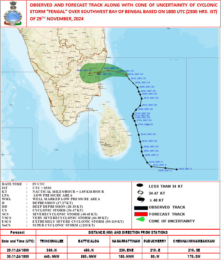
“Cyclonic Storm “FENGAL” over Southwest Bay of Bengal near latitude 11.8°N and longitude 81.7°E, about 210 km southeast of Chennai. To move west-northwestwards and cross north Tamil Nadu-Puducherry coasts between Karaikal and Mahabalipuram close to Puducherry as a cyclonic storm with a wind speed of 70-80 kmph gusting to 90 kmph during afternoon of 30th November.” – IMD update at 2:30 am
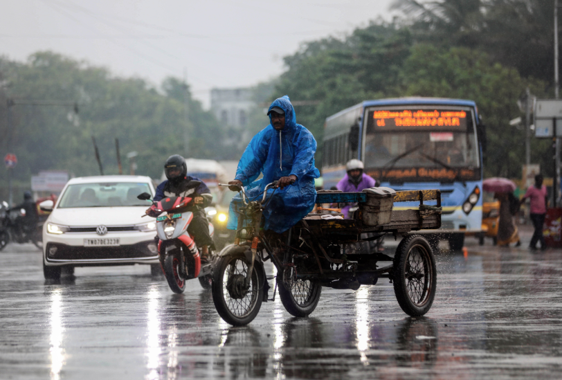
Intermittent spells of heavy to very heavy rain and thundershower with squally winds about (60-70 kmph) will continue at many places of Ariyalur, Chennai, Cuddalore, Dharmapuri, Kancheepuram, Karaikal, Krishnagiri, Nagapattinam, Namakkal, Perambalur, Puducherry, Pudukkottai, Salem, Thiruvallur, Thiruvarur, Tiruchirappalli, Tiruvannamalai, Vellore and Viluppuram over the districts of Tamil Nadu and Puducherry during the next 18-24 hours.
Date/Time: Saturday, November 30, 2024 6:41:15 AM
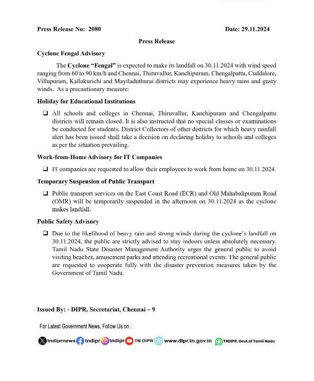
Red alert has been issued across Tamil Nadu: Chennai, Tiruvallur, Chengalpattu, Kanchipuram, Viluppuram, Kallakurichi, and Cuddalore districts, besides Puducherry. An orange alert is in place in Ranipet, Tiruvannamalai, Vellore, Perambalur, Ariyalur, Thanjavur, Tiruvarur, Mayiladuthurai, Nagapattinam, and Karaikal districts.
The IMD has forecast isolated heavy to very heavy rain with extremely heavy rain in Chennai, Tiruvallur, Chengalpattu, Kancheepuram, Villuppuram, Kallakurichi, Cuddalore districts and Puducherry. Heavy to very heavy rain is likely to occur at isolated places over Ranipet, Tiruvannamalai, Vellore, Perambalur, Ariyalur, Thanjavur, Tiruvarur, Mayiladuthurai, Nagapattinam districts and Karaikal area.


